Kilwa
Kilwa - the unknown beauty
Kilwa is the term for a collection of villages on the coast of Tanzania, about 320 kilometres south of Dar-es-Salaam. The villages are called Kilwa Kivinje, Kilwa Masoko, and Kilwa Kisiwani.
Kilwa Masoko is located on a peninsula and is the gateway to the historically interesting Unesco World Heritage Sites on the offshore islands.
There is not much economic activity in the Kilwas, but Kilwa Masoko is the largest fishing harbour on the southern coast of Tanzania after Lindi.
Kilwa Masoko
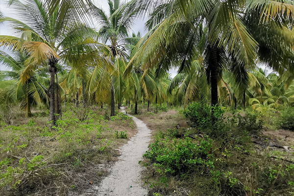
Kilwa Masoko (Kilwa of the Market) is a sleepy coastal town nestled amidst dense vegetation and several fine stretches of beach between Dar es Salaam and Mtwara. It is the springboard for visiting the ruins of the 15th century Arab settlements at Kilwa Kisiwani and Songo Mnara and as such is the gateway into one of the most significant eras in East African coastal history. The town itself is a relatively modern creation with minimal historical appeal.
Sights and activities
On the eastern edge of the town is Jimbizi beach, a short stretch of sand in a partially sheltered bay that is occasionally dotted with the baobab tree. The best coastline is the long, idyllic, palm-fringed open beach at Masoko Pwani, 5 kilometres north-east of the town. This is where Kilwa Masoko gets its fish, and the colourful harbour area is worth a look, especially in the late afternoon.
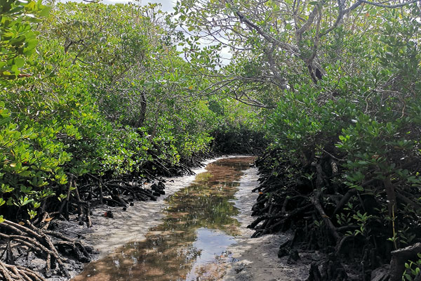
Dhow excursions through the mangrove swamps on the outskirts of Kilwa – interesting for their birdlife and resident hippos – can be arranged, as can trips to see the hippos at Mto Nyange. About 85 kilometres northwest of Kilwa in Kipatimo are extensive limestone caves.
Kilwa Kisiwani
Kilwa Kisiwani, a quiet fishing village in the sun, is situated just off the coast of Kilwa Masoko. In its heyday, it was the seat of the sultans and the centre of a vast trading network linking the ancient Shona kingdoms and the Zimbabwean goldfields with Persia, India and China.
Ibn Battuta, the famous traveller and chronicler of antiquity, visited Kilwa in the early 14th century and described the city as exceptionally beautiful and well constructed. At its height, Kilwa’s influence extended northwards along the Zanzibar archipelago and southwards to Sofala on the central Mozambique coast.
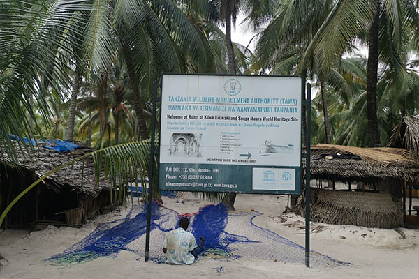
While these glorious days in the past are now well African coast and a UNESCO World Heritage Site; thanks to funding from the French and Japanese governments, significant sections of the ruins have been restored and are now easily accessible, with informative signposts in English and Swahili.
History of the site
The coast near Kilwa Kisiwani has been inhabited for several thousand years, and artefacts from the Late and Middle Stone Age have been found on the island. Although the first settlements in the area date from around 800 AD, Kilwa remained a relatively uninterrupted site until the early 13th century. At this time trade links developed with Sofala, 1500 km to the south in what is now Mozambique. Kilwa came to control Sofala and dominate its lucrative gold trade, and soon it was the most powerful trading centre in the area.
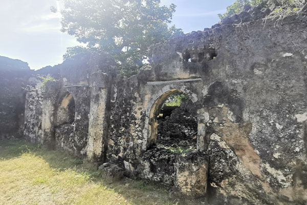
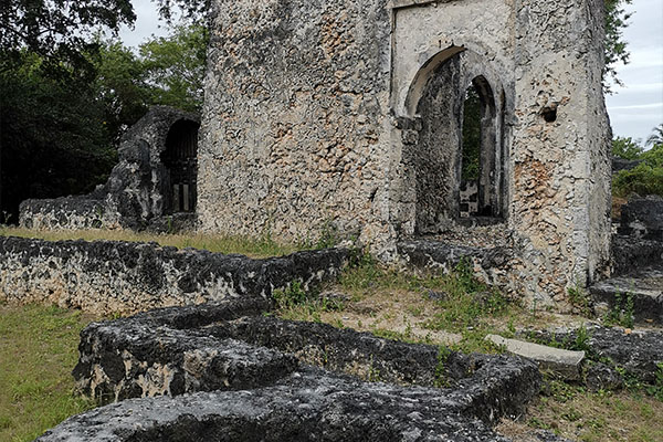
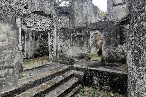
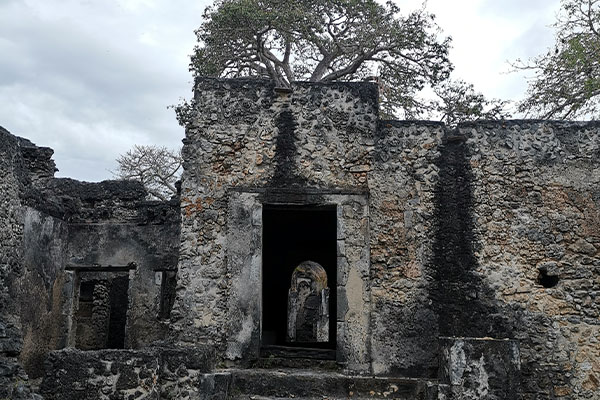
The ruins
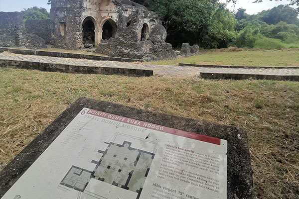
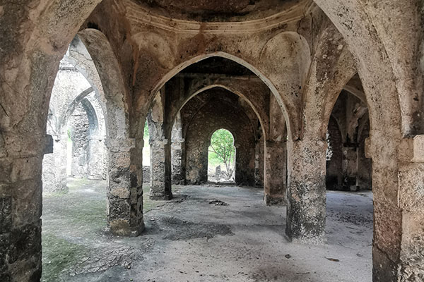
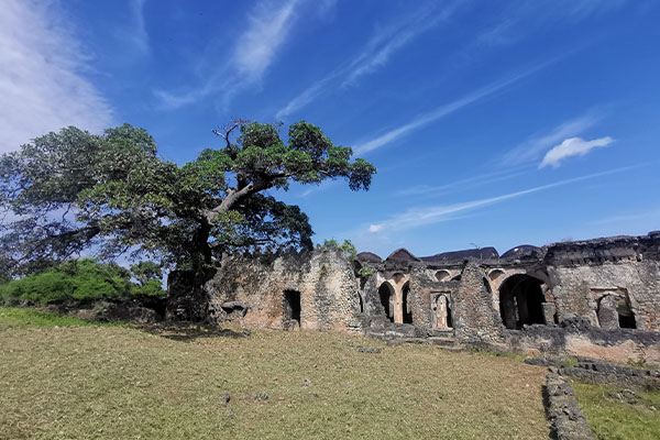
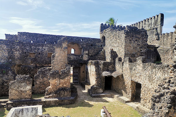
The ruins in Kilwa Kisiwani are in two groups. On approaching Kilwa Kisiwani, the first building you will find is the Arab Fort (Gereza). It was built in the early 19th century by the Omani Arabs on the site of a Portuguese fort from the early 16th century. To the south-west of the fort are the ruins of the beautiful grand mosque with its columns and graceful vaulted roof, much of which has been impressively restored. Some sections of the mosque date from the late 13th century, although most are from additions to the building in the 15th century. In its day, this was the largest mosque on the East African coast. Further south-west and behind the Great Mosque is a smaller mosque from the early 15th century. This is considered to be the best preserved of the buildings in Kilwa and has also been impressively restored. To the west of the small mosque, with large, green lawns and tranquil views over the water, are the crumbling remains of Makutani. Some of the sultans of Kilwa lived in this large walled enclosure. It is estimated to date from the mid-18th century.
Almost 1.5 kilometres from the fort along the coast is Husuni Kubwa, once a massive complex of buildings covering almost a hectare, and together with nearby Husuni Ndogo, the oldest Kilwa ruins. The previous complex, estimated to date from the 12th century or earlier, is set on a hill and must have once offered a great view over the bay. Note in particular the octagonal bathing pool. Husuni Ndogo is smaller than Husuni Kubwa and is thought to date from around the same time, although archaeologists are not yet sure of its original function.
To reach these ruins, you can walk along the beach at low tide or follow the slightly longer inland route.
To reach these ruins, you can walk along the beach at low tide or follow the slightly longer inland route.
Songo Mnara
Tiny Songo Mnara, about 8 kilometres south of Kilwa Kisiwani, contains ruins at the northern end – including a palace, several mosques and numerous houses – believed to date from the 14th and 15th centuries.
They are considered in some ways more significant than those at Kilwa Kisiwani, one of the most complete town layouts along the coast, although they are less visually impressive. Directly on the west side of the island is Sanje Majoma with additional ruins from the same period. The small island of Sanje Ya Kati between Songo Mnara and Kilwa Masoko has a few less ruins of a third settlement in the region, also thought to be from the same era. The best way to get to Songo Mnara is by motorboat from Kilwa Masoko.
Kilwa Kivinje
Kilwa Kivinje (Kilwa of the Kasuarinas Trees) owes its existence to Omani Arabs from Kilwa Kisiwani, who established a base here in the early 19th century after the fall of the Kilwa Sultanate. By the middle of the 19th century, the settlement had become the centre of the regional slave trade network and in the late 19th century a German administrative centre. With the abolition of the slave trade and the German defeats in the war, Kilwa Kivinje’s brief spell in the limelight came to an end. Today it is a crumbling, moss-covered and atmospheric relic of the past with a Swahili small-town feel and a fascinating mix of German colonial and Omani Arab architecture.
The most interesting part of the town is the old German boma (administration office). The street behind the boma is lined with small houses, many with carved doors in the Zansibar style. Nearby is a mosque that locals claim has been in constant use since the 14th century for drying in the sun. Out on the water from here is the busy dhow harbour, where brightly painted boats regularly set sail for Songo Songo, Mafia and other coastal ports. The best way to visit Kilwa Kivinje is an easy half-day or day trip from Kilwa Masoko.
Songo Songo
Coconut groves, low shrub vegetation, about 3500 locals, many birds, a beach and a large natural gas field, which is utilised as part of the Songo Songo Gas to Electricity Project, are the main attractions on this 4 sq km island. Together with Fanjove and several other surrounding islands, it forms the Songo Songo Archipelago an ecologically important area for nesting sea turtles and seabirds. The surrounding waters also host an impressive collection of hard and soft corals. The archipelago, together with the nearby Rufiji River Delta, the Mafia Archipelago and the coast around Kilwa Masoko, has been declared of international importance under the Ramsar Convention. The best beach is in Songo Songo’s south-eastern corner, which is accessed through a coconut plantation. There are no tourist facilities on the island.
Songo Songo is about 30 km northeast of Kilwa Kivinje, from where it can be reached in about 31⁄2 hours with favourable winds from Dhow. Coastal aviation flies daily to Songo Songo from Dar es Salaam, Kilwa Masoko and Mafia.
Photos from Kilwa
INQUIRE Kilwa - the unknown beauty
Start planning your Kilwa – the unknown beauty Tour by filling the form below